
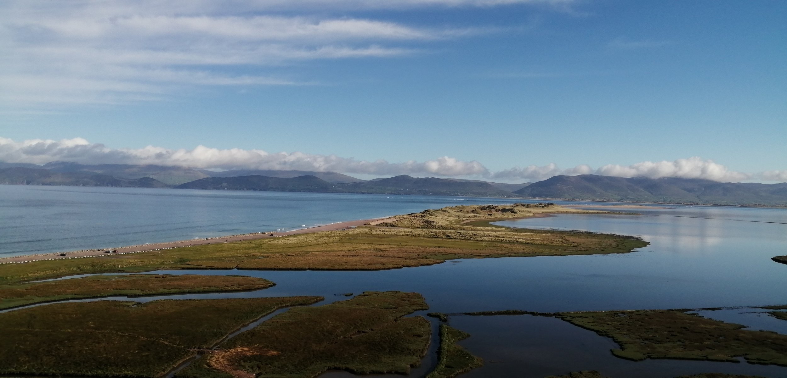
Glenbeigh and Rossbeigh
The area around Glenbeigh and Rossbeigh is underlain by two distinct rock formations. The hills and mountainous regions to the south are composed of Devonian Old Red Sandstone, while the rocks from the base of Curra Hill are composed of Carboniferous limestones and shales.
The Devonian Old Red Sandstones in the area were deposited from around 385 to 360 million years ago. These rocks consist of many layers of sandstones, siltstones, slates and conglomerates which are generally red, purple, grey and green. During this time Ireland was located just south of the equator and the area was much hotter than today. The sediments which form these rocks were carried down from high mountainous regions in the north by river channels and floods and deposited within an extensive floodplain that extended from Kerry in the west to the Commeragh Mountains in Waterford to the east. The Old Red Sandstones are by far the most common rock in the area, covering almost all of the Iveragh Peninsula.
Towards the end of the Devonian, the coastline was gradually moving northwards across this floodplain and by the Carboniferous period, around 359 million years ago, the area was covered in warm shallow seas. These seas hosted abundant marine life including corals, brachiopods, crinoids and fish.The rocks deposited within this environment were predominantly limestones with some sandstones, mudstones and shales. These were generally deposited in flat horizontal layers on the shallow sea floor.
Mountains
One of the most striking aspects of the physical landscape of the Glenbeigh area is the mountains that stretch along the coastline. At the end of the Carboniferous Period, the Iveragh Peninsula got caught up in a mountain building event which had a profound impact on the landscape. As continental plates collided intense pressure squeezed and compressed the once flat lying rocks and piled them up to form a vast mountain chain. This mountain building lasted from around 318 to 290 million years and is known as the Variscan Orogeny. It was during this event that the east-west oriented fold mountains of the Macguillycuddy’s Reeks were formed and the overall ridge and valley landscape of Iveragh was obtained.
Following the mountain building there is a large gap in the geologic record where no rocks have been preserved on the Iveragh Peninsula. Evidence from other areas shows that driving this gap Ireland was alternately covered by shallow seas and hot deserts. The next event which shaped the landscape is the Ice Ages of the Quaternary.
Quaternary Ice Ages
By the Quaternary, our present geologic period which began 2.6 million years ago, Ireland had completed its northward drift and obtained its present geographic position. Around 2.6 million years ago the global climate began to oscillate between periods of warm climate and periods of extreme cold. The glacial deposits and features of the Iveragh Peninsula mostly come from the Last Glacial Maximum, which began around 25,000 years ago. At the time much of southwest Ireland was occupied by an ice body, known as the Kerry-Cork-Ice-Cap, which radiated outwards from an ice dispersal centre near the head of Kenmare River. The dominant direction of ice movement across Iveragh would have been westwards towards the Atlantic. As it moved across the peninsula this ice body was fed by a number of smaller glaciers which formed in the mountains and flowed down to the lowlands. In the area around Glenbeigh there was also a significant component of northwards flow as ice breached the mountains and flowed into Dingle Bay.
As glaciers move across the land, they collect large amounts of debris, rocks and dirt that fall onto the surface of the glacier, are picked up from the underlying earth surface or are pushed and bulldozed by the glacier as it advances. As the ice retreated and melted at the end of the Ice Age, these sediments were dumped and left behind as sheets of unsorted mud, sand, clay, pebbles, and boulders. Deposits of this sediment, known as glacial till are found around Glenbeigh. These till deposits are best seen along the northern coast of Iveragh where they form coastal cliffs.

As the ice began to melt and retreat at the end of the Ice Age vast amounts of debris rich meltwater were produced. This meltwater commonly drained through the low-lying regions between mountains, where it eroded deep meltwater channels. Significant remnants of these meltwater channels are found on either side of Knockboy and Drung Hill.
Throughout the Quaternary, periglacial conditions have also existed in Ireland on numerous occasions and tundra conditions were prevalent in the period following the last glaciation which ended around 14,000 years ago. In these cold, near-glacial areas, intense freeze-thaw activity produced unique periglacial features and landforms. Across the Glenbeigh area a type of periglacial feature known as patterned ground is found. These often take the form of polygons. These formed as ice lenses grown in the soil and the constant expansion and thawing make the ground uneven through frost heave. The ice pushes material to the surface and the coarser stones roll down the side of the uneven ground while the finer material stays in the middle.
River Proceeses
Rivers are modern geological agents that mould and shape landscapes. The form of river landforms depends on a number of factors including the properties of underlying geologic material, the duration the river has been active and the location of the river. Rivers shape the landscape through the erosion, transportation, and deposition of materials such as sand, silt and stones.
Rivers have three stages, the upper course, middle course, and lower course, which each have distinct characteristics and features. The contrast between the upper and lower courses can be clearly seen across the rivers and streams of the area.

The upper course is characterised by having a steep gradient with erosion dominating over deposition. Features found in the early course of rivers include the river source, tributaries, v-shaped valleys, and waterfalls. Examples of upper stage rivers can be seen along the Faha Wood to Rossbeigh trail. Here two streams flow down the hillslope. At this point the gradients are steep and the channels are narrow. As they travelled, the streams have cut downwards and eroded small steep walled valleys in the mountains side.

A series of small waterfalls are found along the westernmost stream. The formation of these waterfalls is likely due to the presence of alternating bands of rock which were overturned during the Variscan Orogeny. Although these bands all belong to the Old Red Sandstone formation slight variations in composition mean that some layers are softer than others. The softer rocks are more prone to erosion so the waterfall forms when water falls onto these softer layers.
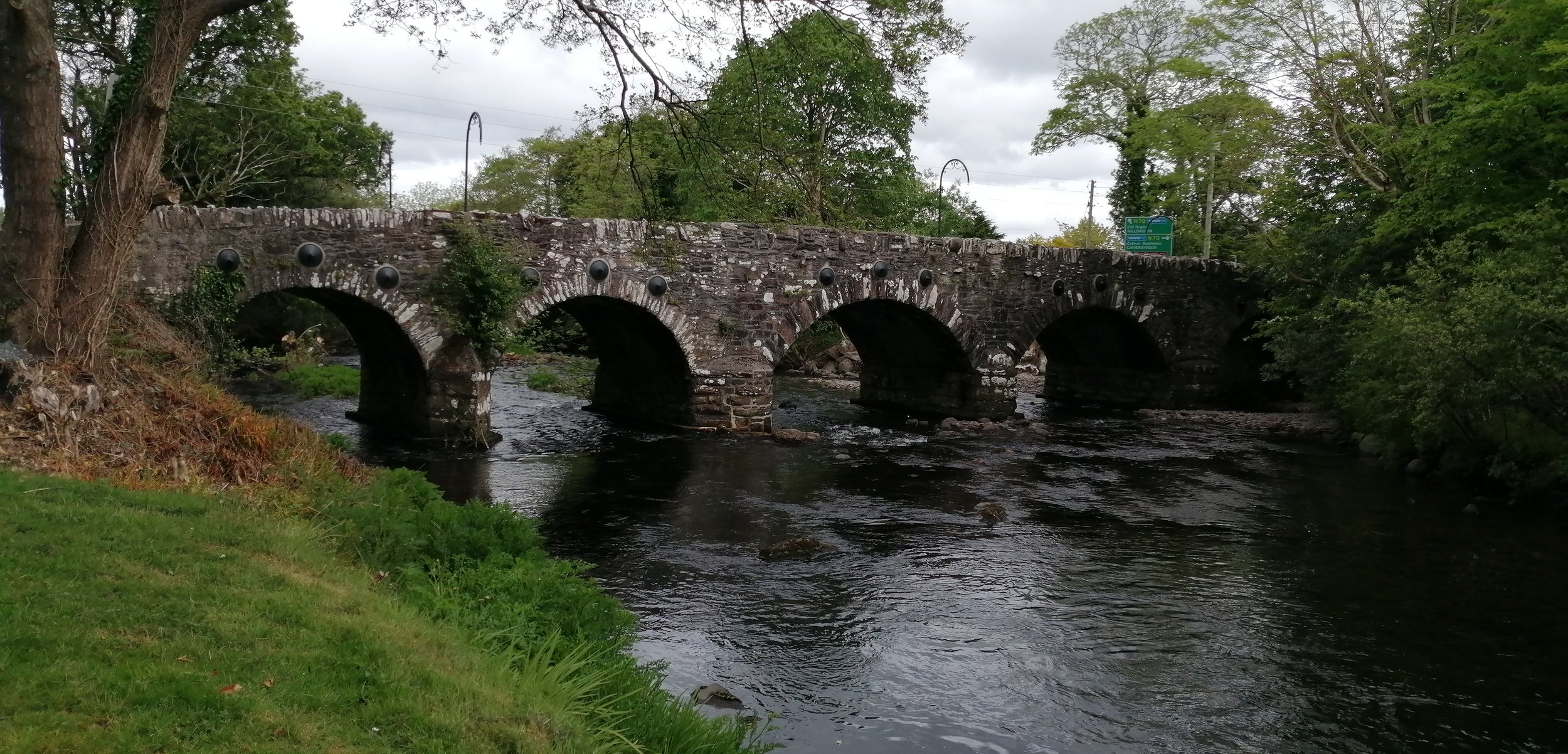
The middle course is characterised by having a gentle gradient with both erosion and deposition occurring. Features found in the middle course of rivers include meanders, slip-off slopes, and river cliffs. The area around the Behy Bridge shows a river at itss middle course. At this point the gradient is very gentle and the river is wide with large meanders. However, the river still flows quite fast at this point, meaning that erosion is still occurring.
Pebble Beach
Across the sand spit at Rossbeigh large pebble sized material has accumulated at the back of the beach. This is a storm beach which forms as this large material is deposited by high energy waves during storm events. These strong waves can carry sediment beyond the normal range of debris and sediment accumulation. As the debris continues to build it may create areas of steeply dipping sediment.
These pebbles vary in size and composition but are overwhelmingly sandstone and siltstones of the Old Red Sandstone. These Old Red Sandstones are dominantly purple, green and grey in colour. The dominance of the Old Red Sandstones suggests that these pebbles have not been transported long distances.
As these are sedimentary rocks they were deposited in rhythmic layers as the sediments accumulated over time, with each layer representing a period of geologic time. These fine layers are known as laminations and are formed by changes in sediment supply. When these layers are very regular and of similar size it suggests that the sediments were deposited by cyclic events such as during seasonal flooding.

When these laminations dip at various angles they are referred to as cross-bedding or cross laminations. The presence of cross laminations indicates flow and that the sediment was being transported and deposited by wind or water movement.
Quartz veins
Bands of white are found across many of the pebbles along the beach. These are quartz veins which formed as hot fluids carrying dissolved minerals from deep within the earth seeped into small fractures and cracks. As the fluid cooled the minerals gradually precipitated, leaving these distinct white bands across the rocks. White pebbles of quartz are also found along the beach.

Jasper
Jasper is immediately distinguishable due to its distinct deep red colour. Jasper is an impure variety of silica which often forms from the aggregation of sand grains. The red colour of jasper is due to the presence of iron.

Black Shale
Black shales are very fine-grained sedimentary rocks which are composed of clay, quartz silt and organic particles. The black or dark colour of these rocks suggest that they contain abundant organic matter. These rocks were deposited in marine conditions.

Chert and Flint
Chert and flint are sedimentary rocks which are composed of very fine-grained quartz with impurities. Flint is grey to black in colour due to the inclusion of carbonaceous matter while dull whitish to pale-brown or grey specimens are called chert. These pebbles generally feel smooth and glassy and show conchoidal fractures (curved fracturing common in materials which lack crystal structure).
Limestone
Limestone is a sedimentary rock which is composed of calcium carbonate. Limestones usually form in shallow warm marine waters. Limestones can form from the accumulation of biological material such as shells, algae and other organic debris or through the precipitation of minerals out of the water.
Seaglass
Sea glass is man-made glass which has been weathered and chemically altered by salt water, which often produces a frosted surface. Over time the glass becomes smoothed and rounded by the waves and currents.
Pebbles with holes
Some pebbles along the beach contain a number of holes. Many of these small holes have been made by marine invertebrates such as bivalves and other molluscs. These molluscs bore holes into the rock using their shells like a drill. This boring usually occurs in bedrock low on the shore and when these rocks break off, they become rounded and worn by the action of the sea and end up as pebbles on the beach.